Icosahedral Vertex-oriented great circle Equal Area
Added in version 9.9.
Alias for +proj=dsea +dual. Drop-in improved version of Icosahedral Snyder Equal Area, with
less obvious cusps. Functionally equivalent to performing a Snyder equal-area
projection using a dodecahedron (Dodecahedral Snyder Equal Area), but then unfolding onto an
icosahedral net.
Snyder's equal-area mapping [Snyder1992] applied to the twelve pentagonal faces of a regular dodecahedron. Each face is subdivided into 10 spherical right sub-triangles, yielding a total of 120.
The icosahedron is unfolded into a planar net and subdivided into 20 × 6 = 120 right sub-triangles. Each sub-triangle is mapped independently using the area-preserving Snyder construction to the 120 dodecahedral spherical triangles.
This is fully equivalent to using the icosahedron directly, but changing the vertex from which the great circles originate from the center of the faces to the vertices, described as the Vertex-oriented great circle projection in [vanLeeuwen2006].
See Polyhedral Snyder Equal Area projections for the shared theory.
Classification |
Polyhedral, equal area |
Available forms |
Forward and inverse, spherical and ellipsoidal |
Defined area |
Global |
Alias |
ivea |
Domain |
2D |
Input type |
Geodetic coordinates |
Output type |
Projected coordinates |

proj-string: +proj=ivea
Orientations
ivea ships a single net (Snyder's Figure 12, shown above). A second named
orientation is available via +orient=pole, which places one icosahedron
vertex on the geographic north pole:
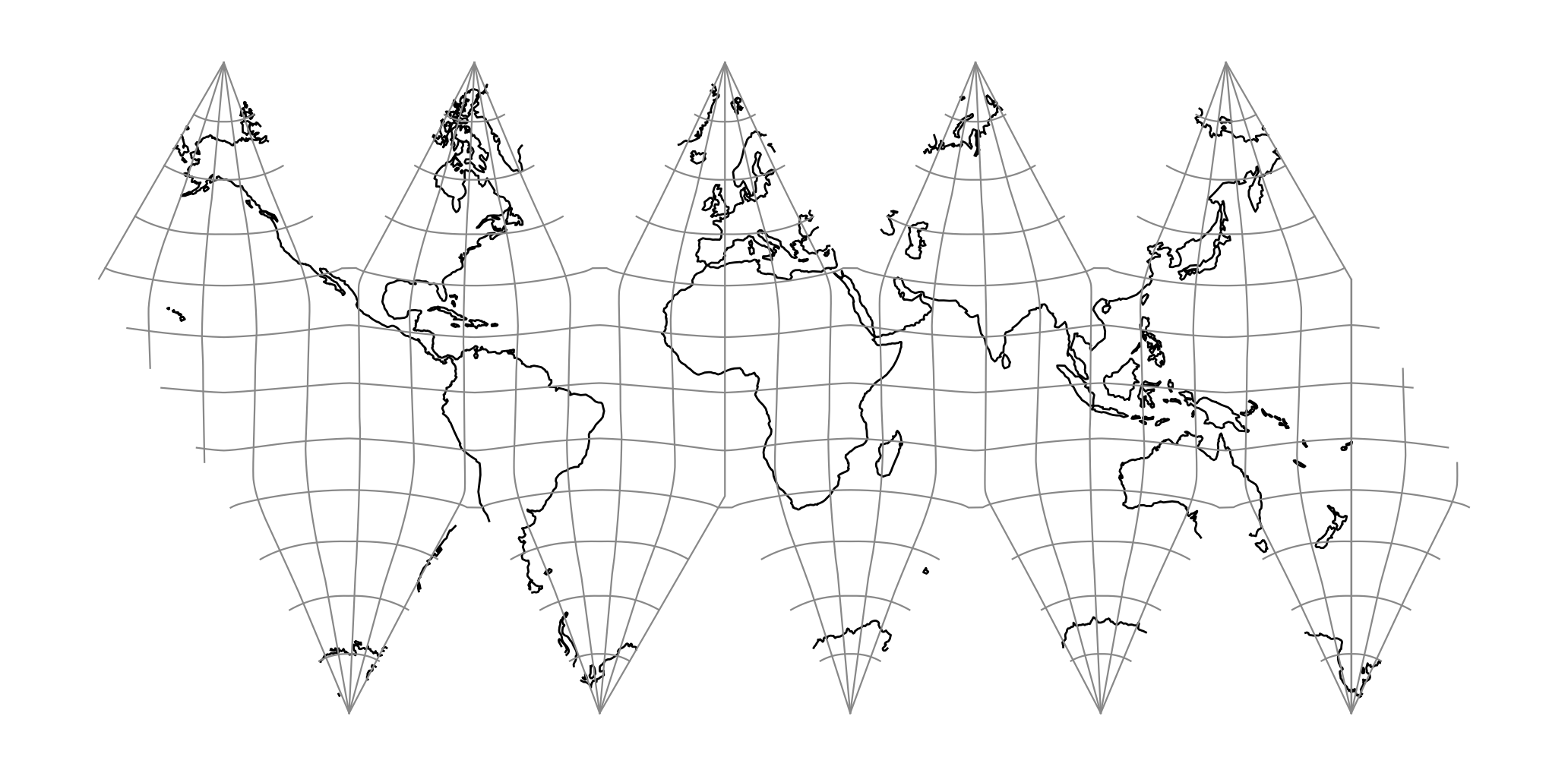
proj-string: +proj=ivea +orient=pole
Parameters
Note
All parameters are optional.
- +orient=<name>
Shorthand for two named orientations. Accepted values:
isea,pole. Equivalent to setting+orient_lat/+orient_lon/+aziexplicitly; individual+orient_*parameters still override.Defaults to
isea.
- +orient_lat=<value>
Geodetic latitude of the polyhedron's first vertex, in degrees. Together with
+orient_lonand+azithis fully constrains the 3D pose of the polyhedron on the sphere.
Defaults to ~58.40° geodetic (arctan(φ) ≈ 58.2825° authalic).
- +orient_lon=<value>
Longitude of the polyhedron's first vertex, in degrees. Together with
+orient_latand+azithis fully constrains the 3D pose of the polyhedron on the sphere.
Defaults to 11.25° on a sphere, 11.20° on an ellipsoid.
- +azi=<value>
Azimuth from the polyhedron's first vertex to its second, in degrees clockwise. Together with
+orient_latand+orient_lonthis fully constrains the 3D pose of the polyhedron on the sphere.
Defaults to 0.0.
- +lat_0=<value>
Geodetic latitude of the geographic point that should land at the projected origin
(0, 0). Used together with+lon_0; the pair translates the projected output without rotating the polyhedron.+x_0/+y_0are applied on top of this translation.When unset, the projected origin falls on the unfold's root face instead (its centroid in general, or its bounding-box centre for
+proj=isea) rather than at a fixed lat / lon.Note
The default convention is to interpret this value as decimal degrees. To specify radians instead, follow the value with the "r" character.
Example: +lat_0=1.570796r
See Projection Units for more information.
- +lon_0=<value>
Geodetic longitude of the geographic point that should land at the projected origin
(0, 0). Used together with+lat_0; the pair translates the projected output without rotating the polyhedron.+x_0/+y_0are applied on top of this translation.When unset, the projected origin falls on the unfold's root face instead (its centroid in general, or its bounding-box centre for
+proj=isea) rather than at a fixed lat / lon.Note
The default convention is to interpret this value as decimal degrees. To specify radians instead, follow the value with the "r" character.
Example: +lon_0=1.570796r
See Projection Units for more information.
- +x_0=<value>
False easting, easting at false origin or easting at projection centre (naming and meaning depend on the projection method). Always in meters.
Defaults to 0.0.
- +y_0=<value>
False northing, northing at false origin or northing at projection centre (naming and meaning depend on the projection method). Always in meters.
Defaults to 0.0.
- +ellps=<value>
The name of a built-in ellipsoid definition.
See Ellipsoids for more information, or execute
proj -lefor a list of built-in ellipsoid names.Defaults to "GRS80".
- +R=<value>
Radius of the sphere, given in meters. If used in conjunction with
+ellps,+Rtakes precedence.See Ellipsoid size parameters for more information.